Historical Spaces in Flavio Biondo's Italia illustrata

A Cognitive-Semantic Analysis in Texts and Maps
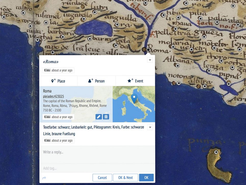
Texts and maps don't just describe or illustrate places – they create them. With a mid-fifteenth-century text, Flavio Biondo's Italia illustrata, as its focus, this project is an investigation into the spaces a literary account of Italy conceptualises by creating a specific syntax that conflates topographical and historical facts dating back to antiquity. The cognitive-semantic analysis of Biondo's text goes hand-in-hand with a study of historical cartographic sources that store and communicate early geoscience in a visual form.

By enquiring into the connections between historical maps and texts we can deepen our understanding of historical concepts of space and of the relevant knowledge and learning. Italia illustrata by Biondo is particularly suited to this task because in addition to presenting a topographical framework of places it also details the history of these places – with the author explicitly pointing out that the country had in fact changed a great deal since antiquity and that his text also had to elucidate these changes. Not least due to this approach, Biondo is now regarded as the real founder of archaeology and of antiquarian topography. In Italia illustrata he frequently cites writers from Ancient Rome, such as Livy, Virgil and Pliny. By contrast Greek thinkers such as Strabo and Ptolemy receive little attention – despite the geographical and topographical contents of Biondo's work and despite his intentions for it. One exception is the chapter on Latium ('Regio Latina'), in which Biondo makes copious use of Strabo's writings in a Latin translation (as yet undiscovered). This chapter has been selected for closer analysis in the first instance.

Having established a topological network of places, whose geographical location Biondo is not always able to precisely identify, he then adds historical information. By this means he constructs a space in the early modern era that is as steeped in ancient learning as it is plagued by anxiety over the loss of learning in its own time. The reader thus progresses through a landscape – described with varying degrees of accuracy – travelling known roads and 'glimpsing', one by one, the places that Biondo discusses.

The cognitive maps that underpin or arise from this description of Italy are central to attitudes to space in the past, because they illustrate spatial knowledge and spatial practices that were specific to that civilisation. In order to pursue a more detailed investigation into the linguistic representation of these maps, use is made of analytical methods developed in cognitive linguistics and computational linguistics, in particular natural language processing and semantic text analysis. The focus is on cognitive-semantic parameters such as toponyms, landmarks, spatial reference-frameworks, geometric relations, Gestalt principles and other diverse aspects that can be discerned by dint of the analytic potential of computational linguistics. Using textual and cartographic markers and by applying quantitative methods specific to this body of materials, the text and the maps are reappraised in context and newly interpreted.

There is also the question, closely related to the above, as to whether – and, if so, how – 'many maps' were indeed consulted by Biondo in the preparation of Italia illustrata, as is generally assumed by those currently researching his work. Since very few regional maps from the early fifteenth century have survived and it is all but impossible to identify literary references to cartographic information, potential alternatives have to be discussed in an interdisciplinary approach (see Workshop). Special attention has to be paid to the strategies Biondo used not only to collect his heterogeneous fund of historiographic, geographic, archaeological and art-historical materials but also to filter and process the latter and to transfer these into a text that his own contemporaries would find 'readable'.
Besides the new translation into English of the chapter on Latium already undertaken by Klaus Geus, other projects in preparation include annotated maps accessible online, essays in interdisciplinary contexts and a compendium arising from the 2018 Workshop, which revolved around the Latium chapter.

Lectures

2018

Thiering, Martin, Görz, Günther, Michalsky, Tanja and Geus, Klaus: Reconstructing cognitive maps in Renaissance texts: A diachronic cultural linguistics perspective. LAUD Symposium: Cultural Linguistics: Current and Emerging Trends in Research on Language and Cultural Conceptualisations, Universität Koblenz-Landau, Landau, 23.–26.07.2018.


Görz, Günther, Tanja Michalsky and Martin Thiering: Spatial Cognition in Historical Geographical Texts and Maps: Towards a cognitive-semantic analysis of Flavio Biondo's "Italia Illustrata". Digital Approaches to Cartographic Heritage, National Geographic Institute, Madrid, 18.–20.04.2018.


Görz, Günther: Raumkognition in historischen Texten und Karten: Ein Werkstattbericht. Kolloquium Baumgärtner, University Kassel, Kassel, 24.04.2018.

2017

Michalsky, Tanja: Geschichte(n) im Raum. Karten als Instrumente von Flavio Biondo und Paolo Minorita, beim Mittelalter und Frühe Neuzeit-Kreis in der Siemensstiftung, Munich, 23.11.2017.

2016

Michalsky, Tanja: Karten im Kopf. Zum Verhältnis von Räumen und Orten in der "Italia Illustrata" von Flavio Biondo, auf der Tagung "Monumenta illustrata. Raumwissen und antiquarische Gelehrsamkeit", Cologne, 26.–28.10.2016.

2015

Michalsky, Tanja: "Italia Illustrata": the interaction of topographical description and cartography in the works of Flavio Biondo and Leandro Alberti, British School at Rome, Rome, 25.11.2015.

2018
Thiering, Martin, Görz, Günther, Michalsky, Tanja and Geus, Klaus: Reconstructing cognitive maps in Renaissance texts: A diachronic cultural linguistics perspective. LAUD Symposium: Cultural Linguistics: Current and Emerging Trends in Research on Language and Cultural Conceptualisations, Universität Koblenz-Landau, Landau, 23.–26.07.2018.

Görz, Günther, Tanja Michalsky and Martin Thiering: Spatial Cognition in Historical Geographical Texts and Maps: Towards a cognitive-semantic analysis of Flavio Biondo's "Italia Illustrata". Digital Approaches to Cartographic Heritage, National Geographic Institute, Madrid, 18.–20.04.2018.

Görz, Günther: Raumkognition in historischen Texten und Karten: Ein Werkstattbericht. Kolloquium Baumgärtner, University Kassel, Kassel, 24.04.2018.

2017
Michalsky, Tanja: Geschichte(n) im Raum. Karten als Instrumente von Flavio Biondo und Paolo Minorita, beim Mittelalter und Frühe Neuzeit-Kreis in der Siemensstiftung, Munich, 23.11.2017.

Görz, Günther: Spatial Cognition in Historical Geographic Texts and Maps: Methods and Theories. University Halle-Wittenberg, Halle, 21.11.2017.

Michalsky, Tanja: Möglichkeitsräume und Grenzen des kartographischen Wissens, auf der Tagung "Neogeographie. Kompetente Partizipation oder Illusion von Demokratisierung", Leipzig, 16.–17.11.2017.

Thiering, Martin: Implicit and tacit knowledge in Flavio Biondo's historiographical and geographical "Italia Illustrata". Streets, Routes, Methods I: Reflections on Paths, Spaces and Temporalities, Kunsthistorisches Institut in Florenz, Florence, 05.–06.05.2017.

Thiering, Martin, Iliushechkina, Ekaterina and Günther Goerz: Ancient Geography Goes Digital: Representation of Spatial Orientation in Ancient Texts. Classical Philology Goes Digital. Working on Textual Phenomena of Ancient Texts. University Leipzig, Leipzig, 16.–17.02.2017.

Thiering, Martin and Guenther Goerz: Spatial Cognition in Historical Geographic Texts and Maps: Methodologies and Theories. Digital Infrastructure for Named Entities Data. Humboldt Chair for Digital Humanities, Leipzig, 11.–13.01.2017.

2016
Michalsky, Tanja: Karten im Kopf. Zum Verhältnis von Räumen und Orten in der "Italia Illustrata" von Flavio Biondo, auf der Tagung "Monumenta illustrata. Raumwissen und antiquarische Gelehrsamkeit", Cologne, 26.–28.10.2016.

2015
Michalsky, Tanja: "Italia Illustrata": the interaction of topographical description and cartography in the works of Flavio Biondo and Leandro Alberti, British School at Rome, Rome, 25.11.2015.

Publications

Görz, Günther and Martin Scholz, "EDEN --- The Erlangen Epigraphic Web Database of Ancient Inscriptions", in Festschrift für Christian-Emil Ore, Oslo, 2018, pp. 31–50. 

Görz, Günther, "Some Remarks on modelling from a computer science perspective", HSR Historical Social Research, Special Issue, ISSN 0172-6404, 2018.

Görz, Günther, Klaus Geus, Tanja Michalsky and Martin Thiering, "Spatial Cognition in Historical Geographical Texts and Maps: Towards a cognitive-semantic analysis of Flavio Biondo's "Italia Illustrata", in Digital Approaches to Cartographic Heritage. 13th Conference of the International Cartographic Association, Commission on Cartographic Heritage into the Digital, ed. Chrysoula Boutoura and Angeliki Tsorlini. Laboratory of Cartography and Geographical Analysis, Aristotle University of Thessaloniki 2018, pp. 29–44.

Thiering, Martin, Einführung in die Kognitive Semantik und Kognitive Anthropologie. [Introduction to Cognitive Semantics and Cognitive Anthropology]. Berlin: De Gruyter Mouton 2018 (textbook).

Events

"Travelling maps". Cartography's Nomadic Languages Across Art, Literature, Politics and Media

Sep 9, 2019 - Sep 11, 2019
Villino Stroganoff, Via Gregoriana 22, 00187 Rom

Flavio Biondo's "Italia Illustrata": Representations of Spatial Language and Spatial Thinking in Text and Maps

Diverse
May 14, 2018 09:00 AM (Local Time Germany) - May 18, 2018 06:00 PM
Villino Stroganoff, Via Gregoriana 22, 00187 Rom

Verkoppelte Räume - Die Kombination von Karte und Bildfolge als mediales Dispositiv

Mar 7, 2018 12:00 PM (Local Time Germany) - Mar 8, 2018 02:00 PM
Villino Stroganoff, Via Gregoriana 22, 00187 Rom
Go to Editor View